The Val de Bagnes is located in the Canton of Valais in Switzerland. It boasts a number of peaks (with the highest being in the Grand Combin at 4,314 m), as well as incredibly diverse and scenic trail running routes which you could spend a week, even two, exploring. The local tourism website has a number of great trail options, some of which I have described below. Those I have featured are all loops leaving from the small villages of Fionnay/Bonatchiesse and following red/white marked trails (i.e. no high alpine routes, more on that later!).
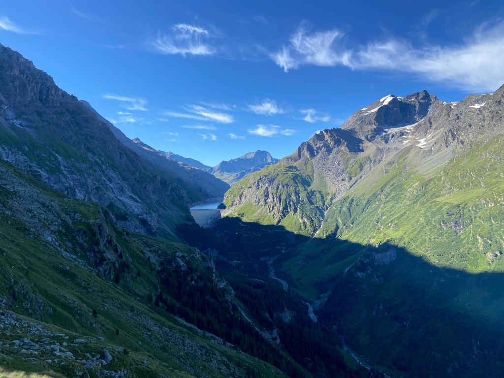
A few tips: if you want to camp, Camping forêt des Mélèzes is a low-key, quiet, and beautifully located campground just outside the (tiny, tiny, literally just a few homes and a restaurant) hamlet of Bonatchiesse. It is located just a few kilometers before the big Mauvoisin dam. The dam itself cannot be seen from the campground, which is a bit of a relief; instead, you will be staring at beautiful green and steep mountains sharply rising to the left and right of the narrow valley. The only catch is that Bonatchiesse and the campground are quite far from grocery stores or other amenities, so not ideal if you do not have a car. That said, there is a bus to Bonatchiesse from Le Châble (which is a bigger town with a grocery store) and other towns in the valley.
Remoteness aside, this is an ideal campground/place for trail runners, casual climbers, and kids. There is a small via ferrata down the road towards the Mauvoisin dam (you can rent the lanyard and other equipment at the campground), there is an easy climbing wall close by (the Madzeira crag – the local crag book can be purchased at the tourist office in Fionnay), there are short and long walks, endless running options, cows, sheep, and goats, a glacier river (be careful with possible water surges), and a small playground. The campground should give you a pass for free use of the Val de Bagnes chairlifts (including up to Cabane de Mont Fort, which is a part of the Walker’s Haute Route) and busses. There is also a small restaurant in Bonatchiesse open part of the week during the summer, and you can order fresh bread from the campground. The Wifi is limited to the camping reception area, but there is decent 4G connection for some mobile carriers (not all).
For navigation and weather, I recommend downloading the SwissTopos and MeteoSwiss apps. SwissTopos is especially great because it will work without cell reception once maps are downloaded, uses the official Swiss maps, and shows you with a little dot where you are. This was handy when navigating some of the runs that follow where cell reception was poor/non-existent. If you drink a lot of water, you could bring a water filter and/or purifier drops as there are a lot of places to refill bottles (although there are animals grazing even as high as 2000m!).
A loop from Bonatchiesse – Écurie du Crêt – Écurie du Vasevay – back to Bonatchiesse
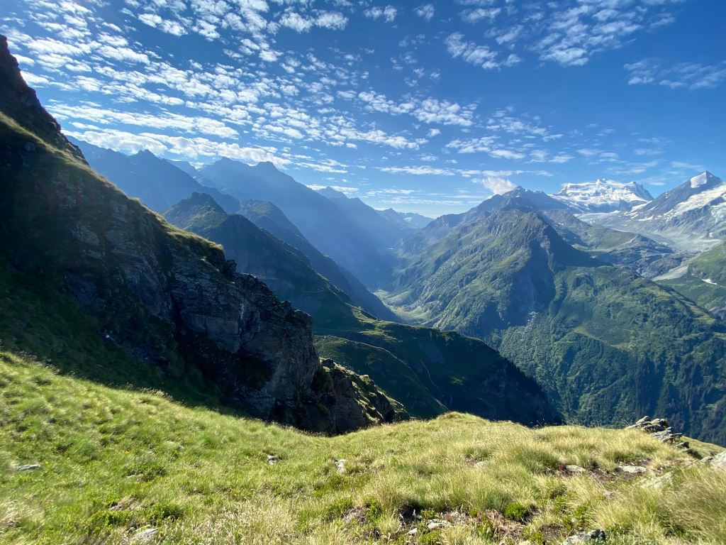
This is a shorter run (about 9 km), although there is significant ascent/descent. It is a great first run if you have not been on the trails in a while and want to get used to a new environment and challenge your legs. The climb from Bonatchiesse to Écurie du Crêt (starting at about 1581m, reaching the Écurie at 2298m) feels very long, but the descent via Écurie du Vasevay is a little more forgiving with a bit of time on a ‘balcony’ like trail before starting to descend more steeply back into the valley to Bonatchiesse. The views over the valley and mountains are just beautiful.
A loop from Bonatchiesse – Fionnay – Cabane FXB Panossière – Col des Otanes – back to Bonatchiesse
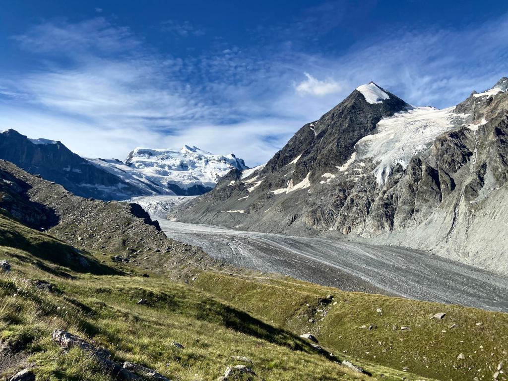
This is another wonderful run (around 18 km on my Garmin). The first stretch from Bonatchiesse to Fionnay is an easy warm-up through valley fields and forests. From Fionnay, the trail climbs steadily to Cabane FXB Panossière. While it is a steady climb, there are brief periods of respite where the path flattens and you can enjoy amazing views over the Petit and Grand Combin and the valley below. Cabane FXB Panossière offers food, coffee, and water before the climb to Col des Otanes (2846 m) and the return to Bonatchiesse.
A loop from Bonatchiesse – Fionnay – Cabane de Louvie – Col du Termin – Col du Bec de l’Aigle – Col du Tête de Sarshlau – Écurie du Crêt – Écurie du Vasevay – back to Bionatchiesse

This was a monster of a “run”! The ascents and descents were numerous and I spent most of the time walking steeply uphill and/or trying to navigate. It was tough to say the least. Once again, the warm-up goes from Bonatchiesse to Fionnay via the valley trail. From Fionnay, I climbed steeply to Cabane de Louvie (2250 m) with its little high-altitude lake, where I was able to refill my bottles (water in the tap outside) and get some food. After that, I took the beautiful trail to Col du Termin (2648m). From there, I took the path to Plan de la Gole (2429 m) and then up to Col du Bec d’Aigle (2566 m). After that, I continued on to Le Da (2377 m) before crossing over the Col du Tête de Sarshlau (2656 m) and then, after a very steep descent after the col, continuing back to Bonatchiesse via Écurie du Crêt and Écurie du Vasevay. This felt like the most remote run that I tried in the valley – after Col du Termin I was very much alone until I reached Col du Tête de Sarshlau.
A loop from Bonatchiesse – around the Mauvoisin dam via Cabane de Chanrion – back to Bonatchiesse

This is a relatively long run (something like 28 km if you leave from the camping in Bonatchiesse). But, it should not feel too arduous because the trails are relatively wide and/or not too busy with rocks or people. Starting from the campground in Bonatchiesse, I ran the main path leading deeper into the campground and then a mix of road and trail to Mauvoisin (use the SwissTopos trail map and watch for the little yellow trail indicators to avoid spending too much time on the road). After the first set of tunnels that got me onto the Mauvoisin dam itself (the 8th highest dam in the world), I crossed the dam and started the trail on the far side of the dam. I followed the trail all the way to the Cabane de Chanrion (about halfway through the run) where I was able to fill my water (despite the grumpy staff!) and get something to eat. The trail is very well-marked, with a just a few more exposed sections. The views are wonderful: gushing waterfalls, cows grazing, rivers running through deep gorges, and a few small lakes. The return run on the other side of the dam was quite easy, with much of it on a wide dirt road and what felt like relatively little ascent/descent. Just before arriving back at the dam, you enter a network of tunnels. Perhaps unpleasant if you are claustrophobic, but a great break from the sun on a hot summer day.
