This 225km hike from Chamonix to Zermatt is an epic walk over an endless series of rugged post-glacier mountains and beautiful green valleys, with the regular dip into quiet, charming Swiss towns. It’s a quieter walk than the Tour du Mont Blanc, and in early July I encountered very few people on the trail. My brother and I ended up walking about a 190km segment, with some detours, of the full hike.
Guiding tools
We used the Kev Reynolds’ guidebook as a general guide as to where to go, but relied on the SwissMaps phone app and a route pulled from Garmin Explorer for actual directions. The route is relatively well-marked, although we found ourselves lost a few times where trail markings were hard to find under snow or rockfall. I would also highly recommend the MeteoSwiss app, which helped us avoid several nights camping in rain and/or lightning and thunder.
Where to stay
The generous thing about hiking in the Alps is there is generally somewhere to stay that is not too far away. We ended up doing a mix of camping (wild, public campgrounds) and staying in refuges when we could not resist a three-course meal or had to shelter against a storm. Camping is much nicer because the dorms get pretty packed unless you’re lucky, which we were because we were hiking relatively early in the season.
An overview of our itinerary
Hikers will find dozens of blogs detailing the route. I’m including here highlights from each day and some photos that will likely entice most people (without a fear of heights) to run to the Alps. Each day followed a similar routine of going up and over a col (usually with the peak at around 2800m, and we did manage a double col day once) and descending into the valley, before another big climb the next day. Most days, we walked somewhere between 5-7 hours. On longer days, we managed to walk almost 10 hours. After a while, the heavy pack stops to matter and you just swim around your own head, pushing your feet up or down the mountains and sometimes stopping to enjoy the breathtaking views.
Day 1: Le Tour (France) to Relais d’Arpette (Switzerland) near Champex-Lac

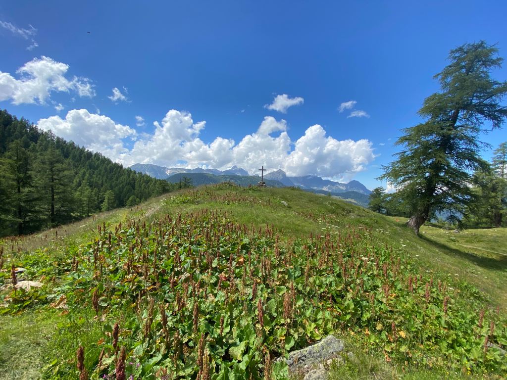
Having hiked a bunch in the Chamonix valley, we decided to skip the first segment of the hike and start at the bottom of the chairlift in Le Tour, a small hamlet just up the valley from Chamonix. From Le Tour, we hiked up and over the Col de Balme (2204m), where there is a small refuge and magnificent views in all directions. From there, we took the most direct descent towards Trient/Le Peuty (the variants looked tempting, but I had already done the Fenêtre d’Arpette on the Tour du Mont Blanc and the weather for the next day was unclear). From Le Peuty, we went back up the mountains, via Col de la Forclaz (1528m), after an impromptu trail-side lunch of pasta bolognese. Starting easy, we took the Alp Bovine variant of the route from Le Peuty, reaching a high point of 2049m before dropping down towards Relais d’Arpette where we camped. This day was mostly beautiful green fields and valleys, rushing rivers, and forests. The last bit required going a bit off route, as the traditional path is to head into Champex-Lac to sleep. We slowly adjusted to wearing very heavy packs and the slow meditation that comes with long ascents and descents.
Day 2: Relais d’Arpette to Cabane Mont Fort
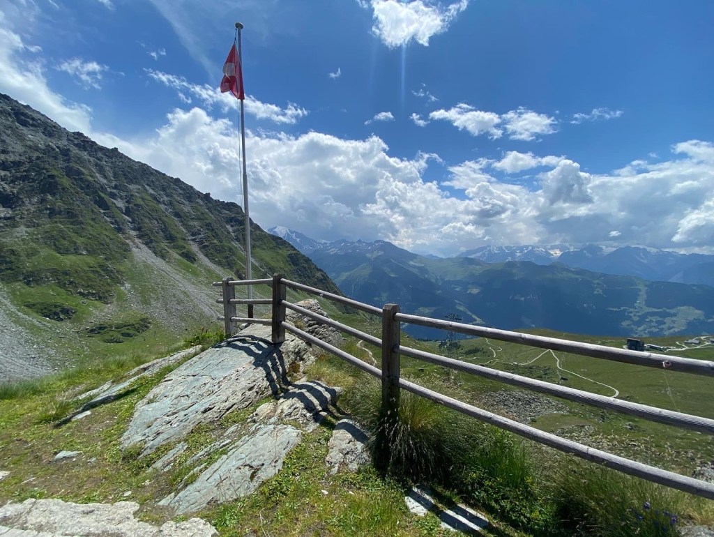
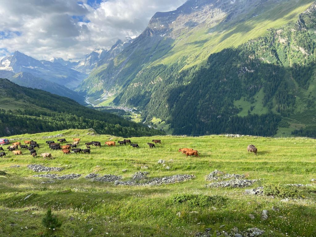
We left the Relais d’Arpette camping with the sunrise and stumbled down to the bakery in Champex-Lac, which was just opening at 6:30 am. A decaf and slice of pie (the first of many, many delicious Swiss pies) and we were on our way. This was mostly a valley day, with significant descent as we picked our way from Champex-Lax (1466m) to Le Châble (821m). The morning presented some beautiful green hills, but the afternoon section between Sembrancher and Le Châble left us a bit uninspired (and perhaps something to skip if you are looking for shortcuts!). That said, we did get to see some interesting working farms and took an absentminded detour to a chapel perched on the edge of a mountain. From Le Châble, we unapologetically took a bus to Verbier and, after purchasing much needed new boots, the chair lift to Les Ruinettes (2195m). From there, we had a lunch of bread and cheese—acquired in Le Châble at the small Migros—in a strange cement block, which turned out to be some kind of art installation, and walked the short distance to Cabane Mont Fort (2457m). We were greeted with wonderful Swiss hospitality and two completely empty dorm rooms. The Cabane is around some of the ski-scarred areas, but it is still beautiful. The mountains around it were alive with the piercing whistles of marmots, and eventually with the explosion of thunder and lightning that we had decided to shelter against towards the middle of the night.
Day 3: Cabane Mont Fort to Refuge Barmaz


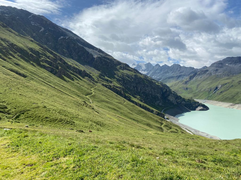
This was a day of intense, mind-boggling contrasts. We started from Cabane de Mont Fort (2457m) and slowly picked our way over snow and boulders to Col de la Chaux (2940m). It was the first truly intense part of the hike where we were both navigationally challenged, concerned about weather (fog), and worried about rock falls. Somehow we made it in one piece to the top of the Col de la Chaux, with great relief. We were greeted with the incredibly austere environment that is left by melting glaciers, and all the instability and risk that they can entail (the Grand désert). Fortunately, the path was better marked after Col de la Chaux as most of the snow had melted and the sun periodically appeared through the clouds. We walked on this moon-like environment for many hours making extremely slow progress over all the boulders and ascents and descents. At some parts, it felt like we were being spat out onto strange foggy beaches, with big misty clouds floating by and glacier melt waterfalls and rivers pooling into large green lakes. It was truly unique.
After Col de la Chaux we passed over Col de Louvie (2921m) and Col de Prafleuri (2987m) before making it down to Cabane de Prafleuri (2624m). The Cabane wasn’t quite open for the season yet but we found a few snacks and then continued on to Refuge Barmaz (2458m). To our surprise, there was a warden from the gymnastic society (which owns the building) taking care of the property as part of her vacation and she was joined by her friends in the evening. Reflecting even more kind Swiss hospitality (and a cultural exchange as they were eager to learn more about Quebec), we were generously treated to fondue, vin blanc, and a breakfast of tartines with coffee. The Refuge is perched above the gigantic Lac des Dix in an utterly peaceful corner of the mountain. After eating and drinking, we slept through a quiet, cold night with little wind. Indeed, a day of contrasts, from the Grand désert left in the wake of the glaciers vanishing before our eyes, to green hillsides dotted with waterfalls, sunshine, and marmots calling. This was perhaps the most special day of them all.
Day 4: Refuge Barmaz to Les Haudères

After Refuge Barmaz, we took the Pas du Chat and Pas de Chèvres—with its fun ladder game at the end and over the col—down to Arolla (2006m), a pretty little town perched on the side of big mountains. From there, we continued down the valley, following a river, to Les Haudères. Right before the Pas de Chèvres ladders we thought we heard a rockfall—but it turned out to be several ibex fighting on a precarious cliff as we walked past. In Les Haudères, a sweet small little village of old Swiss buildings, we spent a substantial chunk of financial resources at the bakery, including the excellent purchase of a slice of rhubarb pie. Too tired for the next col, we slept at the public camping (Camping Molignon) about 1km out of Les Haudères. We managed to find a corner tucked next to the river and far from other campers, so it ended up being a quiet and isolated evening in the end. As usual, Swiss campgrounds are clean, with hot water and better showers than in my own apartment.
Day 5: Les Haudères to Cabane de Moiry


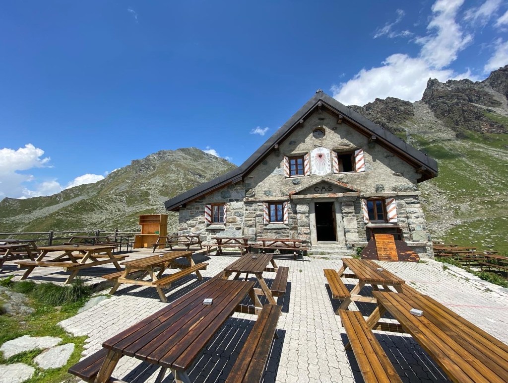
After a night camping just outside Les Haudères, we de-camped with great haste expecting to catch an early bus to La Sage, where we would pick up the trail again. Of course, Sunday mornings are not for bussing and we ended up walking into town, back to the same bakery as the day before. After delaying for an hour on a bench outside—eating and drinking coffee, pie(s), quiche—and watching the early morning world go by, we finally got up the courage to look up and trudge up the impressive flank of the other side of the valley. We made it up to Col du Tsatsé (2868m) and had an excellent high altitude lunch of tea, sandwiches and bread and cheese. With a few candies in our pocket we dropped down the other side of the mountain towards Lac de Moiry. After debating what to do next, we decided to splurge on a night at the Cabane de Moiry (2825m), a fancy, hotel-like mountain refuge parked just on the side of the Moiry glacier with an impressive view over the melting glacier. After scoring another dormitory to ourselves, we ate huge helpings of soup, couscous, chickpea and meat stew and enjoyed another vicious thunderstorm.
Day 6: Cabane de Moiry to Zinal
From Cabane de Moiry, we accidentally dropped down by the road that follows the Lac de Moiry (apparently there is a prettier higher altitude path that we missed, so watch out for that). We then went up from the end of the dam to Col du Sorebois (2836m). After another lunch of rice and tea we cheated our way down on the chairlift and stayed in a hotel in Zinal. Another thunderstorm expected that evening, which eventually started towards the middle of the night with a final shower in the early morning. This ended up being a quasi-rest day, and we found a cozy firepit and picnic bench area next to the river in Zinal to eat a delicious evening meal of pasta and sausages over the little camping stove.
Day 7: Zinal to above Jungen

We marched out of Zinal bright and early after a coffee and sandwich at the local bakery. We went straight up the side of the valley, going over the Col de Forcletta (2874m). After a first lunch of quinoa-in-a-bag and chicken goulash—and the obligatory cup of tea—we nearly rolled down the mountain into Grüben. The part of the hike after the Col was beautiful, with parts including gentle descents so you could admire the view until dropped into the forest. In Grüben, we panicked when we realized there was no grocery store there, but managed to eat a sizeable meal – a second lunch – at the Hotel Schwarzhorn. After that, we gathered up our courage and headed back to do a double-pass day, reaching Augstbordpass (2894m) around 5pm. We then hiked down to the tree line to wild camp just above Jungu/Jungen (1955m). With over 2000m of ascent and 30km on our feet, this was a tough one. Safe to say, we slept very soundly despite the whistling wind in the trees and around our tents.
Day 8: Wild camping above Jungu to the Europahütte
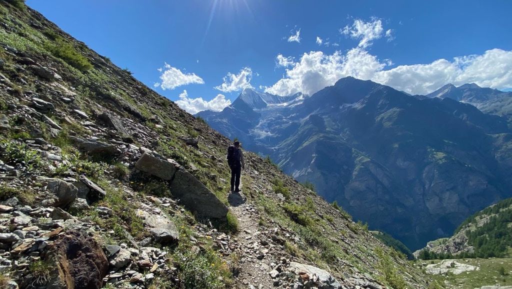

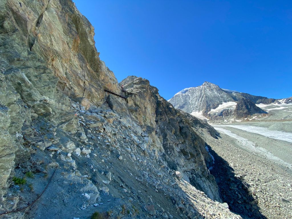
After a peaceful night wild camping above Jungu/Jungen, we walked down to the lift and had a quick coffee and croissant. After that, we took the Jungu lift down to St. Niklas. This wasn’t your typical big ski lift which scars the entire hillside but rather a tiny flying box on a little cable…it was interesting. We saw the mountainside from a whole new perspective, including gigantic tumbling rivers and waterfalls, and the remnants of violent avalanches and rock slides. We visited the grocery store in town and then hiked up to Gasenreid to start the apparently famous Europaweg. We were pretty disappointed by the first five hours on that trail (indeed, I would recommend skipping this segment and starting it at Randa instead), until we were again at an altitude of 2000m or so. There were some uninspiring ups and downs (done to re-route around rock falls, but which basically take you to the valley bottom and back up several times) that were both brutal and without the reward of a view. Things started to look up closer to the Europahütte where we eventually crashed for the night.
Day 9: Europahütte to Zermatt
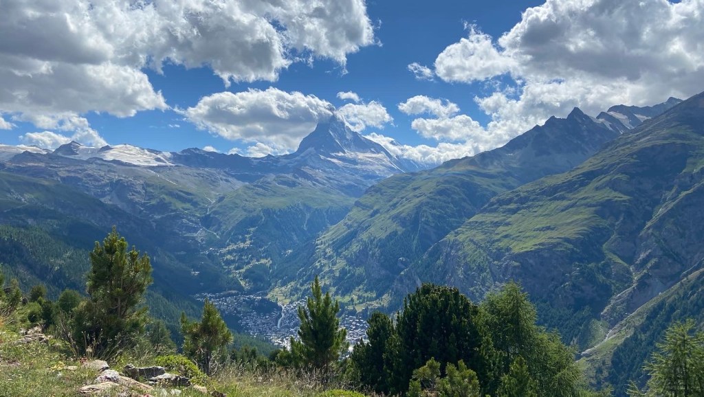


We dragged ourselves out of bed and left the Europahütte around 10 am, long after the crowd dispersed. The second part of the Europaweg was worth the trouble of the first day. We hovered around 2100m for several hours with beautiful views down the valley and eventually over the Matterhorn. It was also a relatively relaxing walk, with few steep ascents and descents. Once near Zermatt, we grabbed the strange tunnel train down to town and deeply regretted not wild camping, as this town was truly an unpleasant shock to the system. We slept at the public camping (preferably to be avoided) and left by 6 a.m. the next day.

One thought on “Hiking the Walker’s Haute Route (France and Switzerland)”
Comments are closed.