The Monte Rosa massif, which is part of the eastern Pennine Alps and straddles Switzerland and Italy, presents a tantalising series of peaks for alpine mountaineers and climbers to ascend, from the Dufourspitze to lesser known peaks like Vincent Pyramid. In early September, we spent four nights at above 3,600m to gauge our capacity for acclimatisation and get a sense of the glacier. While we were originally hoping to summit the Dufourspitze, our plans were waylaid by a combination of factors (namely undertaking this project without a guide, being extra sensitive to bad weather, and a lack of sleep). While we did not make our original goal, the week did not go to waste. A few words follow for those curious about undertaking a similar project.
Getting to the Monte Rosa massif from Milan/Turin (Italian-side)
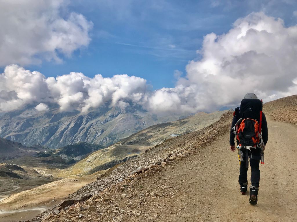
There are different routes to ascending the Dufourspitze, or accessing the various other peaks in the massif (e.g. starting in Italy versus starting in Switzerland). We chose to start from Staffal, in the Aosta valley, on the Italian side. In Staffal, you can jump on a set of three chairlifts (Staffal to Gabiet, Gabiet to Passo dei Salati, and Passo dei Salati to Indren) that quickly take you up to 3,275 meters. Or, you can hike up from Staffal, which looked beautiful, even if hard.
Staffal itself can be accessed by public transit from both Milan and Turin airports. It’s a long trip with several connections. From Milan and Turin, you can catch a Trenitalia train (or many, depending on the connecting schedules!) ending in Pont-Saint-Martin. Pont-Saint-Martin is a sleepy town on the edge of the incredibly beautiful winding valley that leads into the massif. We did not spend much time here, although the old Roman bridge is beautiful from a distance and there is some kind of waning charm to the entire place. There is also a supermarket, which may be important if you have forgotten critical supplies such as…food. From Pont-Saint-Martin, there are several daily busses (bring cash) out of Pont-Saint-Martin to Staffal. The bus schedule is available on the V.I.T.A. website here.
The bus ride from Pont-Saint-Martin to Staffal is full of tight curves and the ear-popping feeling that you are going higher, higher, and then higher. Our noses were glued to the window as the route is tremendously beautiful. The main road passes a series of beautiful, well-kept, and charming Italian villages. Houses adorned with balconies covered in bright pink and red flowers, a wide glacier-green river, and a tantalising assortment of huge boulders in the riverbed just ready for a climb. Staffal is probably one of the less charming villages in the valley, but the best located for the start of the hike because of proximity to the chairlifts. It is also set at 1,834 meters, which may help a bit for a night of acclimatisation if you are coming from sea level. The town is dominated by the (very loud) river that runs straight through it, and boasts only a few stores. Namely, some ski shops and restaurants and bars. If you need any ‘real’ supplies – hiking food, gas for the stove, etc. – those are best bought in Milan or Turin, or in a pinch in Pont-Saint-Martin or Gressoney-Saint-Jean, another slightly bigger town set down the valley from Staffal. Without your own car, however, this village is also hard to reach as the busses that run through the valley from Pont-Saint-Martin up to Staffal operate quite infrequently. In short, it is best to arrive in Staffal prepared with everything you need (not like us!).
There are several places to stay in Staffal – mostly ski lodges that seem to cater to a smaller summer audience. We ended up spending a night at Résidence Walsertal both on our way up and after we returned to the valley from the glacier. The room was spacious and clean, well-priced, and the food was delicious. Our pre-hike dinner was something to remember: dishes of baked potatoes, pasta with deer ragout, warm fresh pizza, a hearty house salad, and chocolate cake. As a bonus, the staff helped us out of a sticky situation by buying gas for us in Gressoney-Saint-Jean and bringing them to us the morning before we left. The morning of our departure to the glacier, we ate a delicious and very hearty breakfast of croissants, pancakes, chocolate cake, cereal, yoghurt, eggs and bread and cheese…along with three cheerful gas canisters.
Where to stay on the massif: the refuges
There are a few options for refuges from which to base your climb (whether to Dufourspitze or other peaks). We decided to stay at Refuge Gnifetti, which is located at 3,647 meters (slightly higher than Refuge Mantova, which can be seen from Gnifetti, and which is based at 3,498 meters). The ascent of Dufourspitze can be made in a day from Refuge Gnifetti if you leave early enough (we were told something like 4-5 a.m. depending on your estimated speed). Another option is to stay at Refuge Margharita at 4,554 meters, which is much closer to the Dufourspitze. While our initial plan was to get to Refuge Margharita and then ascend from there, we eventually decided against it. A friendly guide (who is also the warden of Refuge Mantova) warned us that sleeping that high would be difficult (indeed, my experience had been as much in Colombia on my one prior high altitude ascent). Further, the refuge had just closed for the winter so it would be relatively lonely.
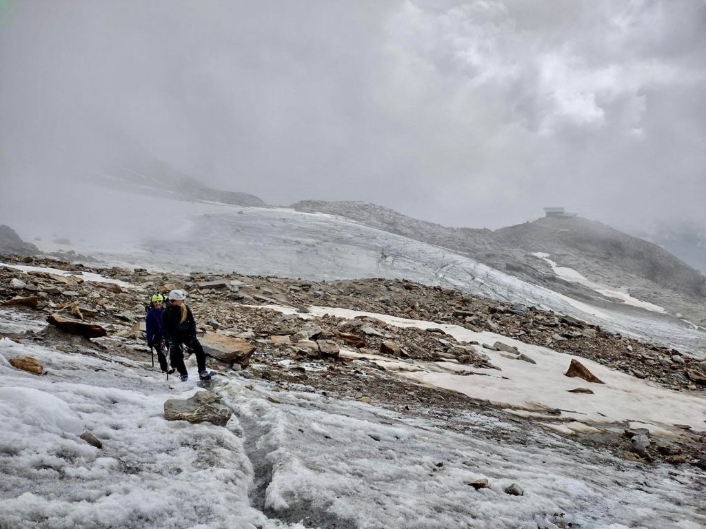
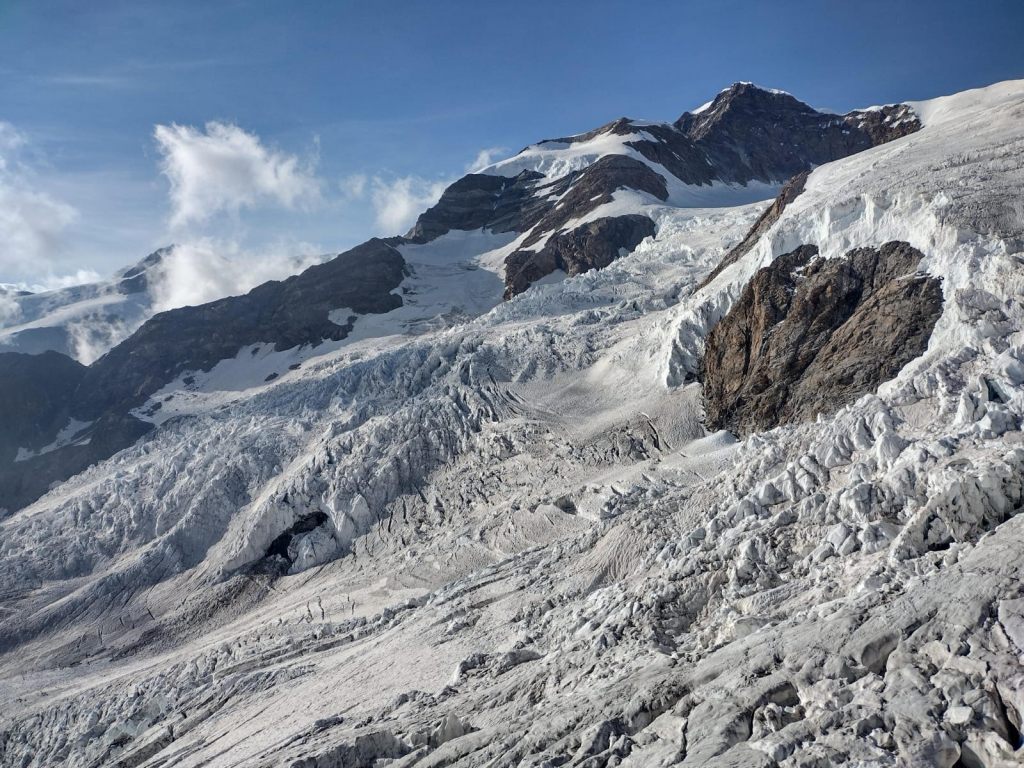
The walk to Refuge Gnifetti from the Indren chairlift was not particularly strenuous. It was relatively easy to navigate with a GPS watch and some light trail markings. It was also quite busy. We roped up a few times when we passed over snow, although we saw a fair amount of people just walking across the glacier snow in crampons without much more. A word of caution: there are a few ladders right before the refuge that cannot be avoided. There is also another section of ropes and ladders before that which we skipped on the way back down by taking the trail from Refuge Gnifetti to Refuge Mantova and then to the Indren chairlift. I personally find ladders and ropes fun – they break up the monotony of walking. We had pretty grim views the day we hiked up to Refuge Gnifetti, but a splendid sight over the valley on the way down. While not as exciting as walking on the glacier, this is still a beautiful walk and at +3,000 m should not be underestimated (i.e. take your time) if you’re not adjusted to altitude.
We would have been happy with a maximum of two nights at Refuge Gnifetti, but we ended up staying four. Staying in a refuge this high up is not going to be a five-star experience, but it was still relatively pleasant. The rooms are clean, although not particularly quiet. We were given a room to ourselves with five beds (possibly because of COVID policies). Guests seem to take seriously the 10 p.m. lights out, though, and most groups are moving out of the refuge the next morning before 6 or 7 a.m. Dinner, which was served at 7 p.m. each night at assigned tables, was huge and delicious. The first night we thought dinner ended with a huge serving of soup and pasta, only for that to be followed with a huge plate of grilled meat and vegetables and bowls of ice cream and fruit. The refuge also serves lunch, although it gets expensive so we brought our stove and dried food (it turns out couscous mixed with rice is delicious when you’re hungry and tired). Breakfast is less interesting, but the serve-yourself-policy means it is relatively satisfying and you can cram a few packages of cookies and crackers for a mid-hike snack. The coffee is terrible.
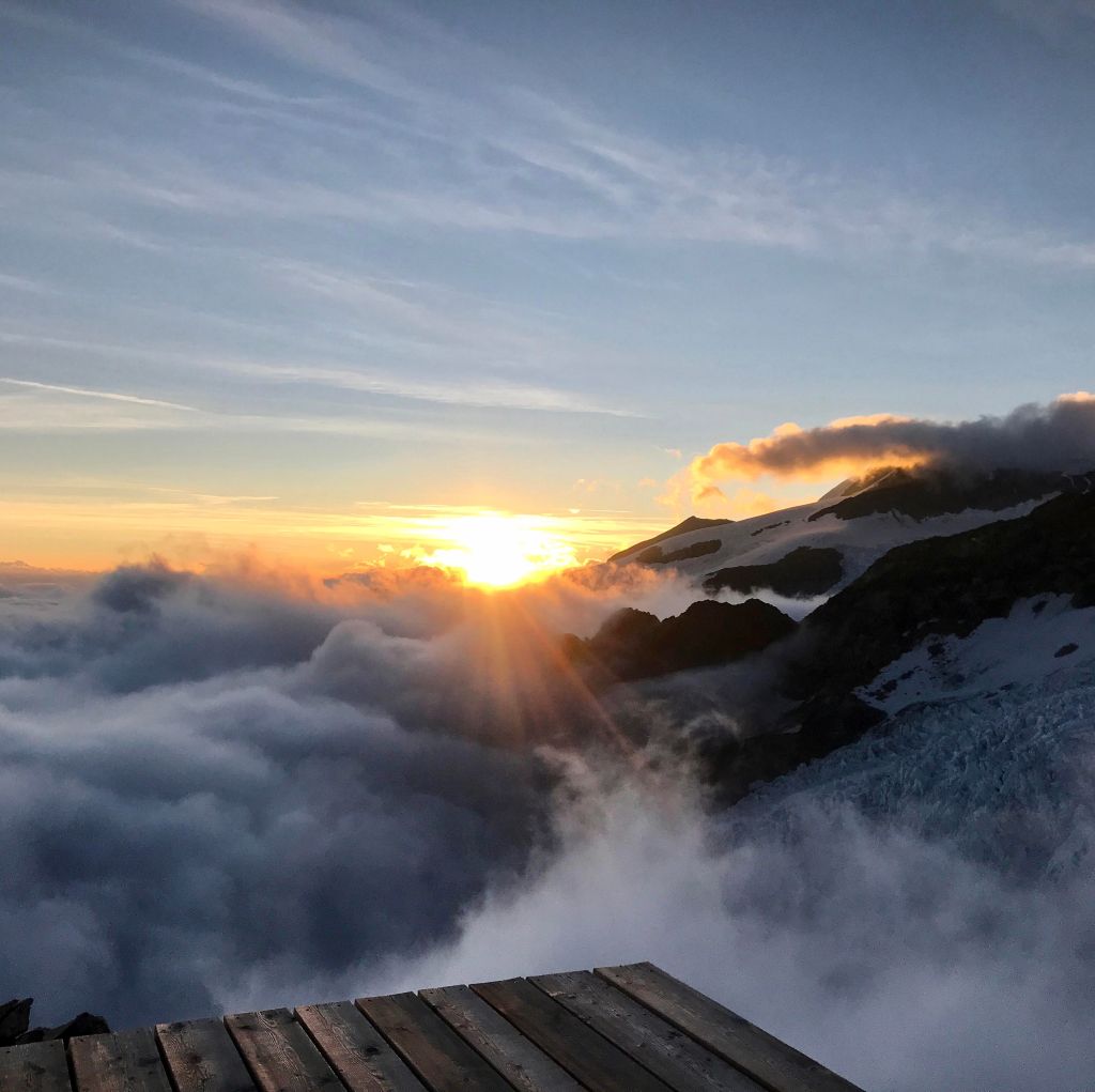
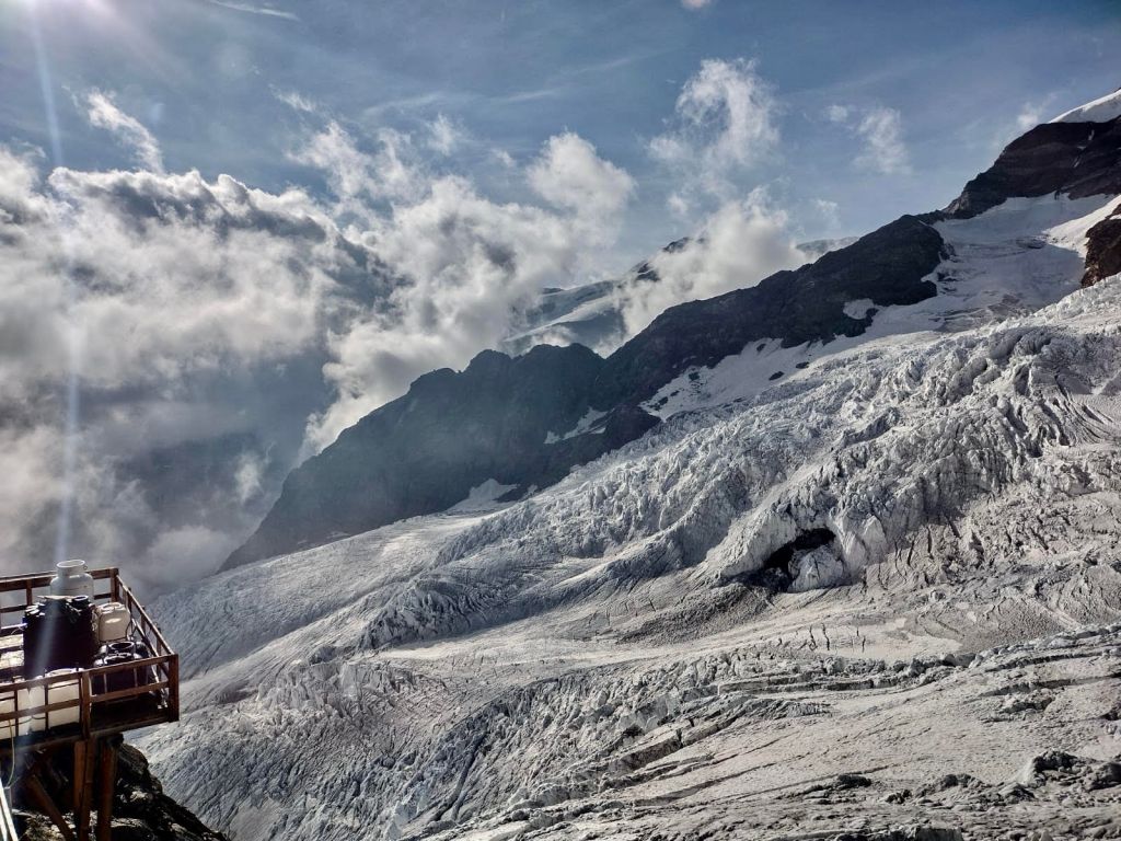
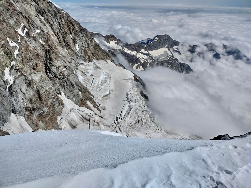
One key thing to remember about Refuge Gnifetti is water. There is no potable water. The water from the tap in the bathroom comes from the glacier, so we brought tablets to purify the water and bottle it. Another option is to buy water at the refuge, but it adds up very quickly (both in plastic bottles and in euros). I was not too impressed with this, particularly the amount of plastic that must be used by guests. In any case, the view-from-the-loo is not something to be missed (image below). There is also a terrace up a flight of stairs near the bathroom that leads to some incredible views (also below).
Things to do on the glacier (i.e. how to pass the time)
I got the sense most people at Refuge Gnifetti were there on guided tours with specific peaks in mind (e.g. the Dufourspitze). There are no shortage of options from Refuge Gnifetti (a good summary here). As a beginner, I was a bit envious of the guided tours – they were likely making the peaks they wanted and did not have to worry about much while on the glacier, aside from putting one foot in front of the other. However, without a guide, you learn a tremendous amount when nothing is handed to you and you have to navigate the complexity of being on a glacier with your hiking partners. So, while we did not make the Dufourspitze this time, we learned a lot – and saw a lot – with the time we had. There are plans to return for another peak.
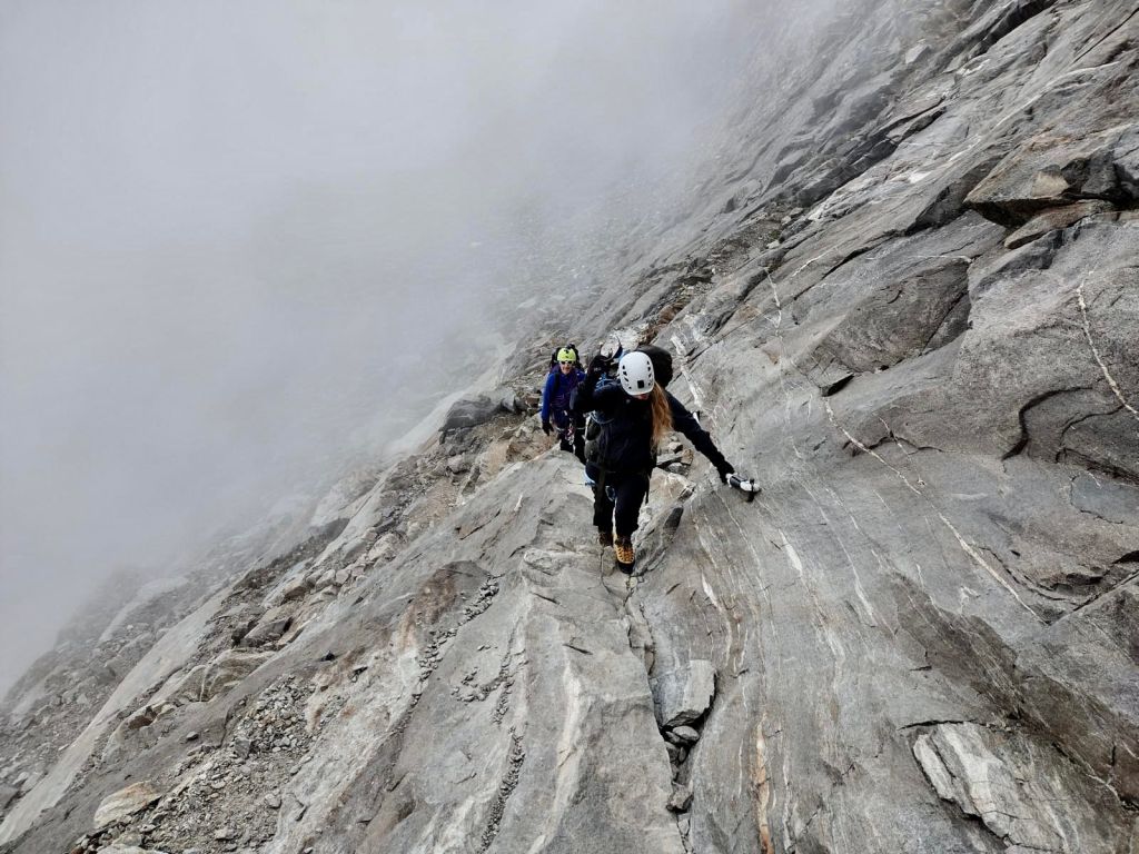
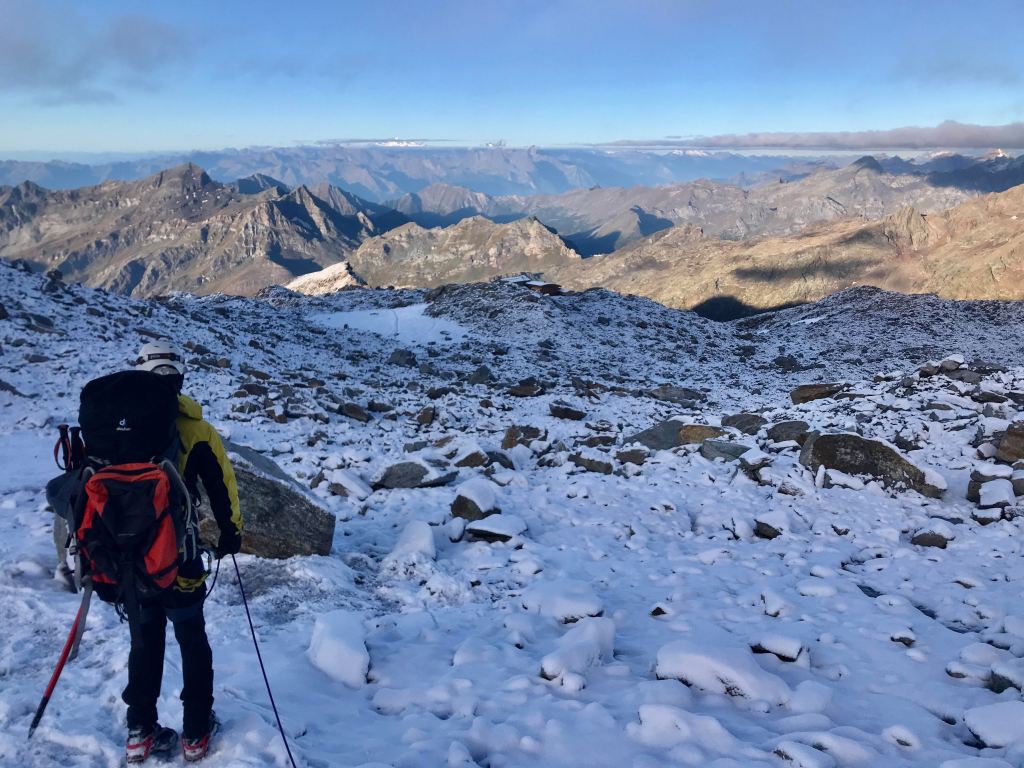
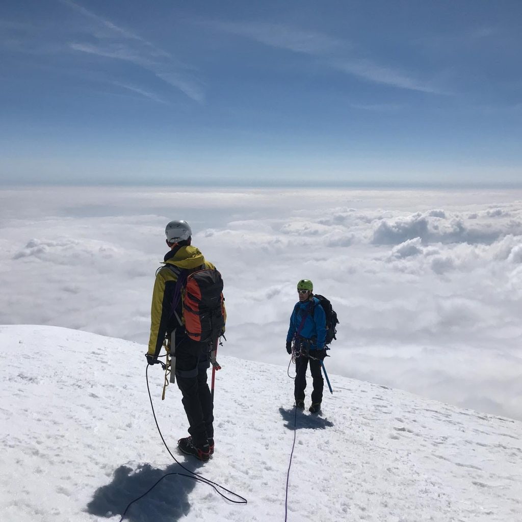
We spent one morning running through crevasse rescue techniques and then we marched off in the direction of Vincent Pyramid. There are several approaches to this peak. One is along a rocky crest that starts from below the refuge. Another approach – which we opted for – is walking across the glacier. From the ladders at the refuge (the ladders located higher up on the glacier), there is a pretty well-marked path (in the sense that it has been walked a lot) that leads around a tricky section riddled with crevasses and then up towards the peak. While the path is relatively obvious, it was useful to have a GPS device to confirm we were going the right direction and not wandering into a minefield of crevasses and holes.
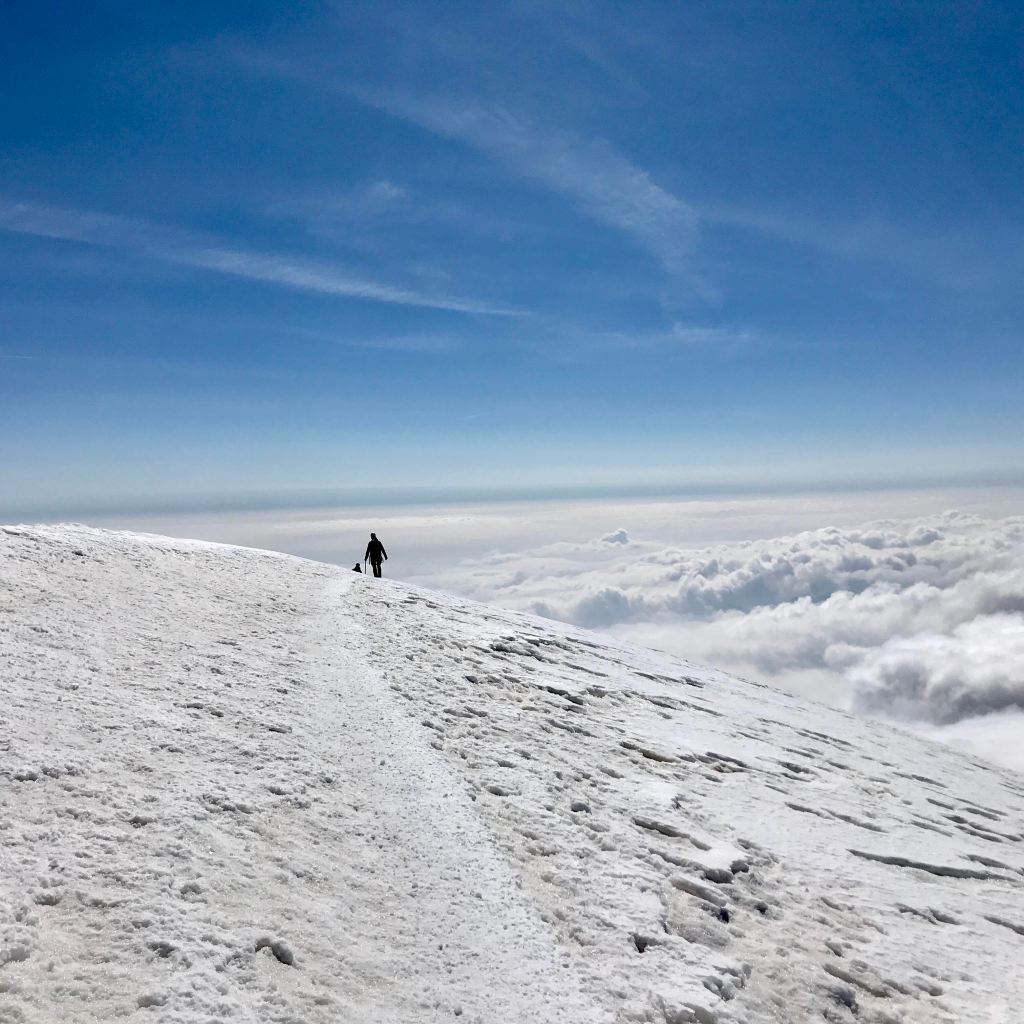
This ended up being the only true peak we made during the trip, but it was well worth it. The hike up is not that strenuous (via the non-crest route), although there are some pretty impressive crevasses to jump over and navigate around. The top of Vincent Pyramid itself is flat and wide, so there is no technical difficulty in ascending. It is also a really easy peak to pick out in the horizon because of its distinctive flat shape. At 4,215 m, we had the feeling of floating above the clouds. There are many beautiful things in this world, but – to me – mountains put our existence into a broader, impenetrable perspective of all that the world contains.
In addition to the peak, we explored the rocky crest that is part of one of the routes up to Vincent Pyramid, which was good practice in navigating rock and ice with crampons. We also practiced a bit of belay techniques and using ice screws on the ice wall that is just below the refuge and took a spin towards Col de Lys.
A few words on managing expectations
This was our first glacier walk as a team of three, and with me being the least experienced (and most risk-averse). We were faced with a few challenges, including a stomach virus, one short bout of dehydration, and really shifty, rather unpleasant weather on most days. The next attempt, I think, will be a much shorter, harder push to the top and then just…back home. I am also tempted to walk at some point in the future from the valley floor to spend a night at Refuge Mantova, before going up to Refuge Margharita.
