Earlier this year, I set my sights on accomplishing the Tour du Mont Blanc solo, camping, with little prior experience. A brief survol follows. This was an incredible hike, and one I can highly recommend to anyone dipping their toes into through-hiking. I did the 180 km or so loop, with a number of variantes, in 7 days. This was a physically and mentally demanding and rigorous schedule (with the usual schedule being 10-11 days, without variantes). Those seeking more enjoyment should slow down, something I am incapable of doing (yet).
Day 1: Les Houches to the aire de bivouac (camping site) near Refuge Nant Borrant via Col de Tricot variante
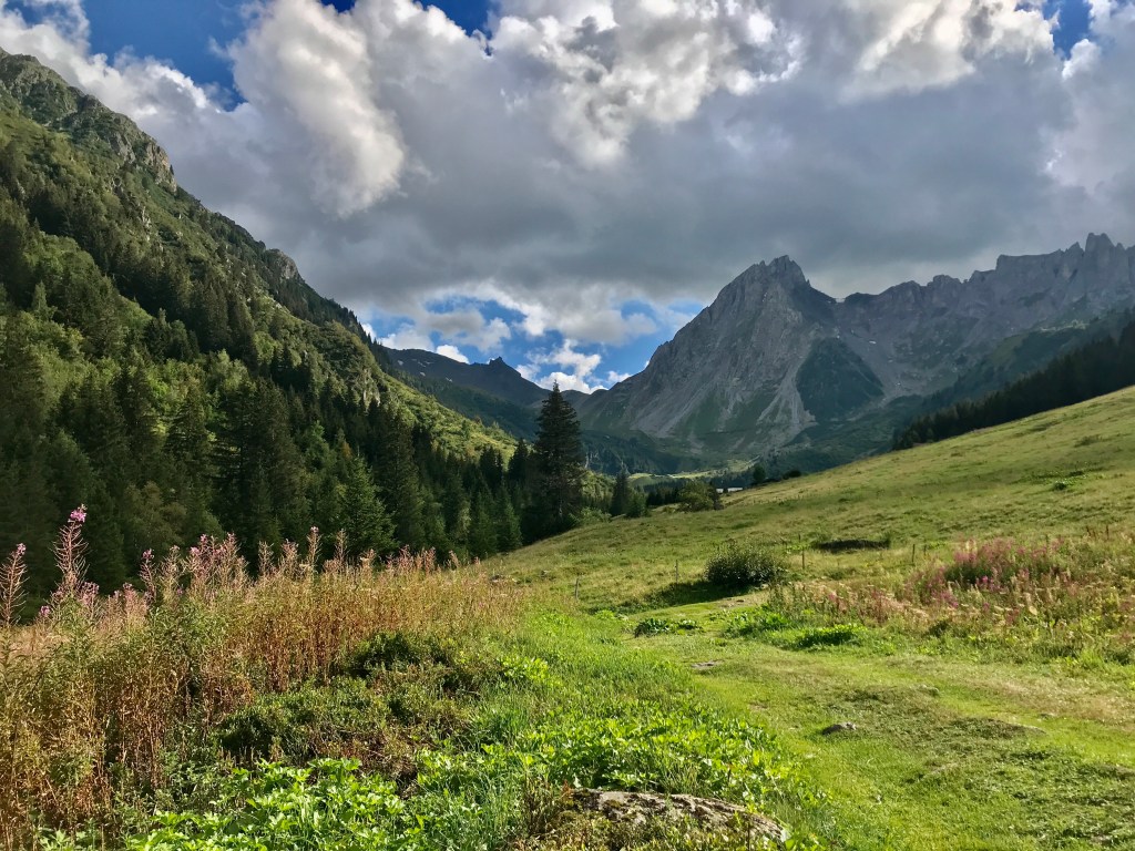

I started the trek (anti-clockwise, as is “traditional”) in Les Houches, spending the night at the dorms in Gîte Michel Fagot (great food, brisk but efficient service, clean dorms). While the initial ascent out of Les Houches was comparatively underwhelming to the rest of the tour (but still physically trying), I was glad to have skipped the télé-siège from Les Houches as this gave me a chance to warm-up to my 15kg+ bag and enjoy the cool morning air. Having spent most of the summer in heat and near the sea, it was a wonderful sensation to smell the damp forest and view snow-capped mountains as the ascent began around 7:30 a.m. Already, magical. I followed the Col du Tricot variante, which included a fun suspension bridge passage, among other joys, and had lunch at the Refuge de Miage. Beer, sandwich, a stupendous view of the mountains. After lunch, I walked on to les Contamines, a charming little town that was just setting up for a street market. After buying a dried sausage the size of my hand, I continued on. While my initial plan was to stay at the campground in les Contamines, a kind fellow traveller (the first of many), recommended that I aim for the aire de bivouac at Refuge Nant Borrant. Arriving around 4 p.m., I was greeted by a clean grassy area next to a rushing river with a view of the mountains. A peaceful place to rest for the night.
Day 2: Aire de bivouac (camp site) near Refuge Nant Borrant to a site near Refugio Elisabetta (into Italy)
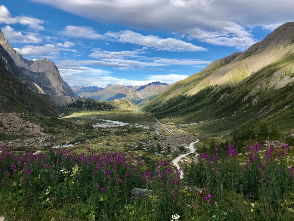
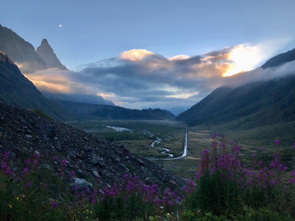
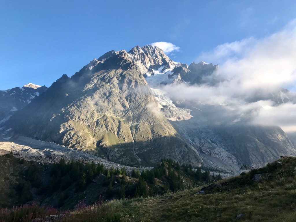
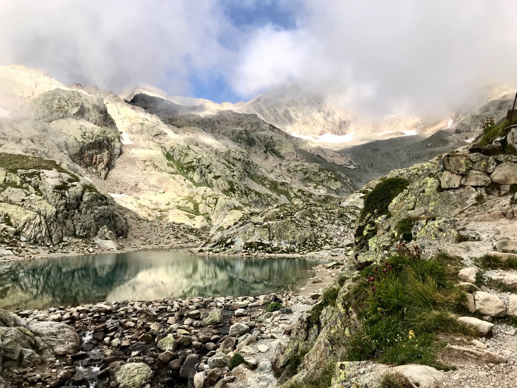
I left the camp site around 6:30 a.m., unable to sleep for long in the tent (a problem soon cured by intense physical exhaustion). The morning light was magical and I walked up and past Refuge de La Balme (which also has an aire de bivouac). Distracted by the beauty of the slow and then steeper ascent after La Balme, I took a wrong turn and followed a gushing waterfall up a mountain, all the way to Lac Jovet (which can also be added as a variante on the Tour du Mont Blanc). Realizing I was turned around, I panicked and rushed down the mountainside. Next time, I know to enjoy the unexpected surprise of not knowing where you are, while being surrounded by stunning beauty. The lake was still and quiet in the morning and the mountains make a wonderful game of sound; one moment, the waterfall is so loud it is hard to hear one’s thoughts, and suddenly a blanket of quiet envelopes. Retracing my steps, I took the Col des Fours variante, ascending one of the highest points on the traditional Tour du Mont Blanc. While the Col des Fours was beautiful, I was perhaps more stunned by the magic of le Col de la Croix du Bonhomme, just before. Safe to say the descent after the cols to Ville des Glaciers was utterly brutal under strong sunshine. Over the course of the trek, I quickly learned to loathe descents–which require intense concentration making enjoyment of the view, or anything else, complicated–and to appreciate the slow, steady nature of the ascent. After lunching at Refuge Les Mottets just after Ville des Glaciers (delicious pasta, lots of cheese), I decided to keep hiking and eventually made it to Refugio Elisabetta around 7:00 p.m. A long day. My stove stopped working so I ate an emergency ration of chile con carne before falling asleep to the sound of rain and wind.
Day 3: A site near Refugio Elisabetta to a site near Refugio Walter Bonatti

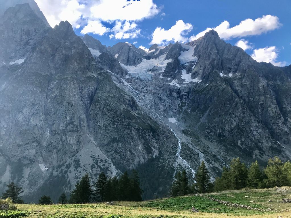
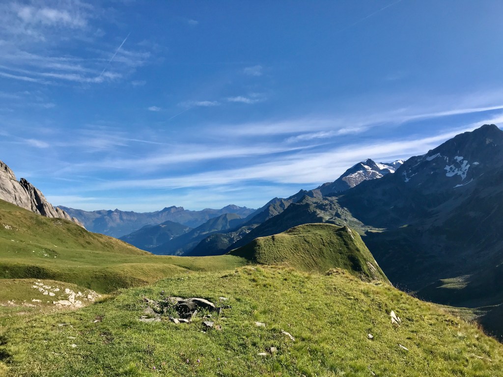
I woke up early and began walking through the valley below Refugio Elisabetta. The light was magical, with the snow capped glaciers reflected in small lakes and clouds and fog slowly lifting. If you are someone who enjoys waking early, there is little more satisfying than starting a walk hours before the rest of the crowd–particularly on a trek as busy as the Tour du Mont Blanc. For many hours, I found myself wondering alone in the mountains and down valleys, undisturbed. This was one of the favourite parts of the trek, as the path leading out of the valley provided spectacular views of the snowy mountains. Over and over again, I had to stop and marvel at the exquisite size of these giants. As I began to near Col Chécrouit (a ski area), the fog began to roll in and I walked through a quiet forest, arriving far before any tourist crowds. After a croissant and a coffee, I began the agonizing descent into Courmayeur. If there was one spot on the tour to take a télé-siège, this would have been it. I persevered. In Courmayeur, I ate an entire pizza in under five minutes, a beer, and coffee. I had forgotten about Italian riposo and was unable to restock fuel for my failing stove (the Triangia spirit burner is no match for the stove I later bought, the Primus gas; the efficiency of burning alcohol available for the spirit burner was very, very poor). I filled up water and marched on. The ascent to Refugio Bonatti was boiling hot, but with constant and seemingly unending views of the mountain. A wonderful German couple shared their delicious pasta dinner with me, as I was still hobbled by my lack of stove.
Day 4: A site near Refugio Walter Bonatti to the campground in La Fouly (into Switzerland)


Again, rising early and leaving before 7:30 a.m., I began walking a few hours before the rest of the crowd. This walk was particularly pleasant, in that it began on the side of the mountain with minimal ascent and descent. Eventually, I was dropped–knees aching again–into the valley before the ascent to the Col Ferret. I continued on, assuming I could get a coffee and some warm food at Refugio Elena, which turned out to be closed. After a cold meal of oatmeal-in-a-pouch, I began the ascent to Col Ferret. The remarkable change in geography from Italy to Switzerland was particularly acute here. On the Swiss side, long rolling green mountains began, the chime of cow bells in the distance. I stopped to dry my tent in the warm late morning air and I fell asleep on the side of the hill, among wildflowers and wind. After Col Ferret, a long-ish descent into the first Swiss valley, stopping for lunch at Alpage de la Peule (a place you will appreciate if you love cheese). I took a wrong turn after the Alpage and ended up on the car road to La Fouly, but I eventually refound the trail which wanders down the side of a rushing river. I stopped for a while to read my book and cool my tired feet, arriving at the campground at La Fouly around 3 p.m. (I also made a brief detour to the sports store in La Fouly, which was staffed by absolutely lovely people who helped me assemble my new stove). The campground in La Fouly was busy, formal, expensive, and full of amenities (hot water, wi-fi, coffee, etc.). I pitched my tent next to the rushing river (which, I have now learned, is a guarantee for a good night’s sleep as it crowds out the sound of people putting their tents up after hours). Dusk brought quiet over the campground and the surrounding mountains.
Day 5: La Fouly campground to the campsite at Relais d’Arpette
This was an easy walk through small Swiss towns and valleys and finally ascending to Champex-Lac and then on to the Relais d’Arpette. The ascent to Champex was a sudden surprise and strain, but easy compared to prior days. The forests along the way were quiet and shady, a nice break from previous days of heat. It rained a bit, but nothing horrific. In Champex-Lac, I made my way to the bakery Gentiana and stocked up on some goods, while demolishing a quiche and another coffee. I was undecided about what to do next, but finally settled on hiking up to Arpette in case I had the gumption to try the Fênêtre d’Arpette variante in the morning (which was also indicated to be weather dependent). This turned out to be a brilliant decision. The hike up to the Relais was beautiful, following along a small rushing river that provided enough distraction that I was surprised to reach the Relais so quickly. Further, the Relais d’Arpette has a quiet and intimate campsite, which would make this place a wonderful site for a rest day, and delicious, generous dinner. The staff were wonderful. The restaurant manager took one look at my huge heel blisters and fixed them up, leaving me with some medicated cream to apply. The campsite was quiet after dusk, and I slept soundly.
Day 6: Relais d’Arpette campsite to the campsite at La Boerne in Tré-le-Champ (back into France)
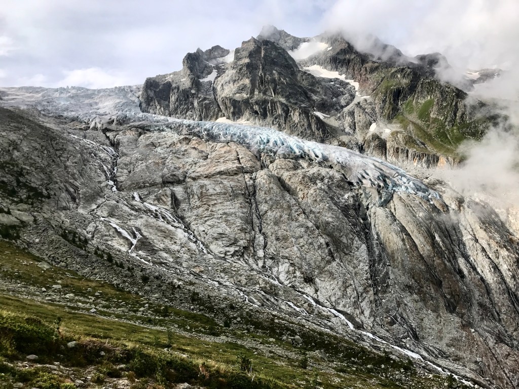

This was one of my favorite days. I left early, along with a few others, while the sky was still cloudy. While it was threatening to rain, which would have made the ascent difficult and dangerous, the weather held and the sun began to burn away the fog. The ascent to the Fênêtre was hard because it required scrambling up large boulders with a massive hiking pack. Without the bag, I think this would have been a relatively easy stage all things considered. The other complication was the challenge of finding the path, and the threat of ending up on the wrong peak, looking down at an impassable descent. Along with a French couple, we were able to navigate to the peak which provided a clear and stunning view of the receding glacier on the right-hand side. Staring down, it was not immediately obvious how one could descend from that height, but the trail ended up being fairly stable (and comparable to some I had experienced in the Dolomites–steep but manageable). Knees screaming, I ended up safe and sound at the Buvette du Glacier du Trient (delicious pies, coffee). After a brief break, I began the ascent to Refuge les Grands (closed due to COVID) and then on to Col de la Balme. I loved this section–the forest provided intermittent shade and I could see the steep mountainside I had just descended across from me. At Refuge les Grands, I had a sandwich and then continued to Col de la Balme. The path required some scrambling and holding on to chains, but for the most part was relatively flat, affording a chance to enjoy the beautiful mountains all around me. At Col de la Balme, I took the shorter descent to Tré-le-Champ, regretting it later since it mostly tracked the ski areas. At La Boerne, I pitched my tent next to the river and joined in a delicious dinner of turkey, pasta, and cheese.
Day 7: The campsite at La Boerne in Tré-le-Champ to Les Houches

This ended up being a monster day (about 12 hours), unintentionally. At first, I thought I would head to Lac Blanc and then stay around La Flégère, but I lost interest after seeing the ski hills that surrounded the area and I ended up carrying on to Les Houches. I left early in order to beat the crowds heading up to Lac Blanc, considered to be a popular spot, and was pleasantly amused by the series of ladders required to scale up the straight cliffs that formed some of the path up to the Lac. At the Lac, I had a coffee at the Refuge, but was slightly put off by the rather rude staff. It was cold up there, too. The descent to La Flégère was pretty, but crowded by a lot of day tourists heading up to the Lac. After La Flégère and the mess of ski hills, I was almost ready to call it quits by Col du Brévent. I did not, which was the right decision. The final passage from Col du Brévent to les Houches provides this remarkable and melancholic full view of the Mont Blanc mountain chain. It was hard not to stop every few meters and marvel again and again.
Concluding thoughts. There is such an exquisite balance of pain and pleasure in the mountains. The pain of ascending and descending many kilometers, but that also being the vehicle to this feeling of complete and total freedom. Standing under giants like the Mont Blanc can put much into perspective. How temporary we are, how unique and valuable the physical world around us is, and how much there is to enjoy and preserve. It is a wonderful place to learn.
